Jan 10
2013
Buffalo shatters temperature record

Some weather experts believe the record-breaking heat in 2012 is a warning that the frequency of extreme weather will increase in Western New York and the nation.
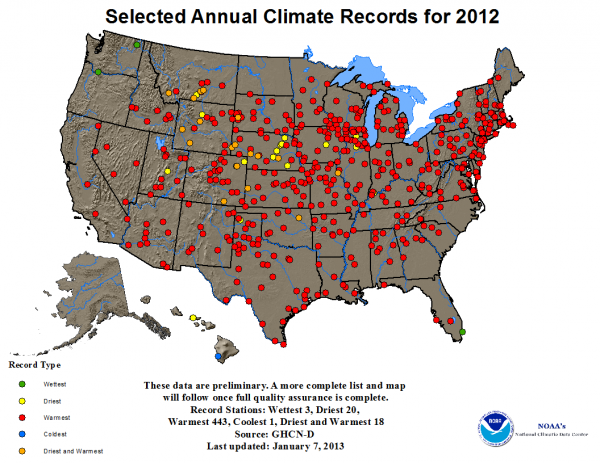
The average temperature in the United States for 2012 was 55.3 degrees, which is 3.2 degrees above the 20th Century average, according to the National Oceanic and Atmospheric Administration’s State of the Climate report. The new record national average temperature is 1 degree hotter than the previous one, set in 1998.
The temperature climbed even more in Buffalo.
In 1998, Buffalo recorded its highest average temperature at 50.9 degrees. This record was shattered in 2012 by 1.2 degrees to 52.1 degrees, according to Chris Fenimore, a climate scientist for NOAA’s National Climatic Data Center.
“That is amazing because things don’t jump like that normally in a year,” said Stephen Vermette, a climatologist and professor of geography at Buffalo State.
March was 13.4 degrees above normal, said Dave Thomas, a meteorologist with the National Weather Service. Remove that month from the temperature equation and Buffalo would have had only a 0.1-percent increase in average temperature for 2012.
What does it all mean?
Weather experts said one cannot take a single year of data and draw climate change trends, but the big picture does tell an ominous story that could have major impacts in Western New York.
“What I drew from it was it was a very warm year for the continental United States. The report will tell you it was the warmest year on record,” said WGRZ meteorologist Andy Parker. “It means it was a warm winter and a hot, dry summer for Western New York.”
But, he cautioned, “to look at one year and say this is going to be the new norm, that is not how it works.”
Fenimore and Vermette provide the bigger picture.
Fenimore said the nation’s average temperature is increasing about .13 degrees per decade.
“The trend does show an increase in temperatures and is in line with all of the climate assessments that have stated that these extreme events—warmer temperatures, larger outbreaks of drought —will be increasing in the future,” he said.
NOAA says the nation experienced 11 disasters last year that each cost more than $1 billion in losses. Disasters included the yearlong drought, wildfires and Hurricane Sandy, which ranked as one of the costliest storms ever to taxpayers, with some estimates as high as $80 billion.
Vermette said temperatures and precipitation measurements will always fluctuate, but the big picture shows a slow, upward climb.
“The overall trend, if you stand back, is going to be a continuous rise in temperatures. My thinking is, it has to do with greenhouse gases.”
Higher temperatures and less rain means low water levels and a host of problems for the Great Lakes.
For example, warmer water temperatures further depletes oxygen in the lakes and promotes the release of contaminants from bottom sediments, according to a Union of Concerned Scientists study. Invasive species, such as the zebra mussel, can thrive in these conditions; fish cannot.

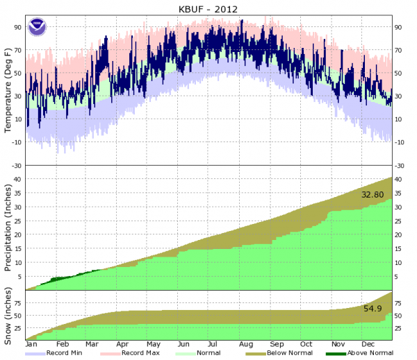
Each graph shows monthly totals and monthly normals. The first graph measure temperature, the second measures precipitation and the bottom one measures snow.
The normal precipitation for Buffalo is 40.48 inches, but only 32.80 inches were recorded in 2012, making it the 32nd driest in 142 years, according to Thomas at the National Weather Service.
Water levels in Lake Huron and Michigan were at record lows for December. Lake Erie’s record low is 568.7 feet in 1934. In December, the water level was 570.3 feet. The average water level for Lake Erie in 2011 was 571.7 feet, meaning levels have dropped by more than a foot during that period.
Vermette said lower water levels will have a huge impact on shoreline infrastructure. For example, he said, ships are already having to “light-load,” or carry fewer goods, because the water isn’t deep enough in some parts of the Great Lakes.
“Western Lake Erie is very shallow and there are dredged channels in the lake to allow ships to travel,” he said. “With existing conditions, it is just going to exacerbate this.”
Vermette said scientists in this area have been predicting for a long time there will be warming temperatures and less rain. When it does rain, it may be heavier or more extreme, he said.
“Conditions will get worse over time if this trend continues and we think it will continue. So what may have been an extreme year back in 1950 will suddenly become a norm in the 2020s,” Vermette said.
Other key data for 2012:
- Lowest temperature: 2 degrees on Jan. 15
- Highest temperature: 96 degrees on Aug. 4
- March was an average 47.4 degrees, which is 13.4 degrees above normal
- Precipitation total was 32.8 inches. The norm is 40.48 inches
- Highest daily rainfall: 1.42 inches on Oct. 29 (Hurricane Sandy)
- Highest daily snowfall: 10.1 inches on Dec. 26
Related:

